Enregistrez gratuitement cette image
en 800 pixels pour usage maquette
(click droit, Enregistrer l'image sous...)
|
|
Réf : T01485
Thème :
Terre vue de l'espace - Volcans (181 images)
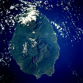
Titre : Réunion Island May 1992
Description : (La description de cette image n'existe qu'en anglais)
Oval-shaped Réunion Island, one of the Mascarene Islands, is shown in this low-oblique, southeast-looking photograph. The island is 39 miles (63 kilometers) long, is 28 miles (45 kilometers) wide, and covers 970 square miles (2150 square kilometers). The island is similar to the big island of Hawaii because both are located above hot spots in the Earth’s crust. Piton de la Fournaise, a shield volcano on the eastern end of Réunion Island, is partially obscured by clouds in this photograph. The volcano, which rises more than 8565 feet (2611 meters) above sea level and is sometimes called a sister to Hawaiian volcanoes because of the similarity of climate and volcanic nature, has erupted more than 100 times since 1640. The brown volcanic flows are visible in the photograph. Piton des Neiges Volcano, the highest point on the island at 10 069 feet (3070 meters) above sea level, is west of Piton de la Fournaise Volcano near the center of the photograph. Collapsed calderas and canyons are southwest of the mountain. Like Mauna Kea on the big island of Hawaii, Piton des Neiges is extinct. The slopes of both volcanoes are heavily forested (dark green). Cultivated land and cities like the capital city of Saint-Denis are concentrated on the surrounding coastal lowlands. Sugar is the chief agricultural product and export.
|
|

